Victory Track
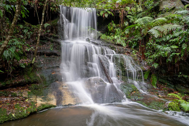
6km: The Victory Track in Faulconbridge, NSW, is a classic Blue Mountains bushwalk, starting near Sir Henry Parkes’ grave and following Sassafras Creek through lush gullies. The walk most commonly begins near Faulconbridge Station, with popular segments leading to Clarinda Falls and beyond to other valleys. Distance: The Victory Track from Faulconbridge to Springwood is approximately 6 km, taking in Clarinda Falls, while a longer route continuing to Blaxland extends the distance to about 15 km. Time: Faulconbridge to Springwood via Victory Track takes roughly 3 to 4 hours for the standard walk, or up to 5+ hours if continuing further towards Blaxland. Track Features: Highlights include Clarinda Falls, Sassafras Creek, rainforest scenery, and occasional creek crossings. The track is moderately challenging, with some steeper and rocky sections. Victory Track is accessible from Faulconbridge Station, making it easy to reach by public transport. It is a rewarding trail for hikers seeking a mix of history, natural beauty, and waterside walking. BACKSTORY: The Victory Track was built between 1878 and 1887 to connect Faulconbridge with Clarinda Falls and the Sassafras Gully, an area officially declared a reserve in 1888. Originally called "The Long Track," it was renamed after World War I to commemorate the Allied victory. The track is part of a network of trails developed during a late 19th-century boom in Blue Mountains track construction, including the nearby Wiggins Track built by local apiarists. The Victory Track holds historical significance for its role in early bushwalking and access to scenic natural areas in the Blue Mountains. The track starts here: https://w3w.co/lastly.sludgy.encounters PHOTO: Clarinda Falls by www.DavidNoble.net https://www.facebook.com/AskRozBlueMountains/posts/great-news-victory-track-reopens-after-three-year-closurethe-victory-track-conne/1163121775841917/
 google.com